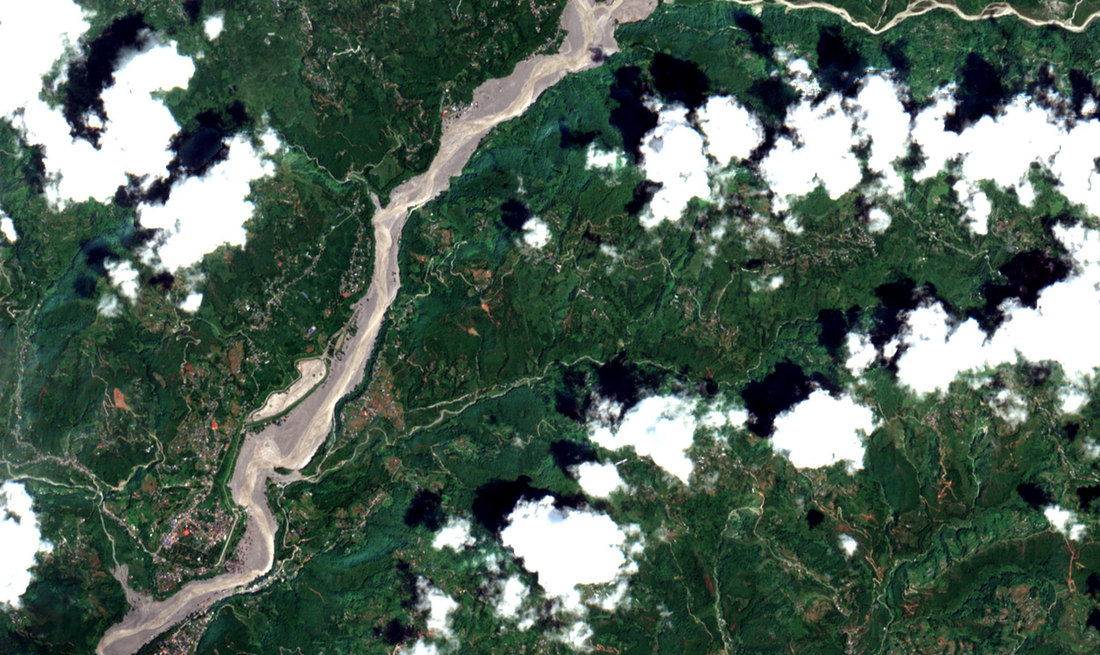
 27 Aug 2026 — after
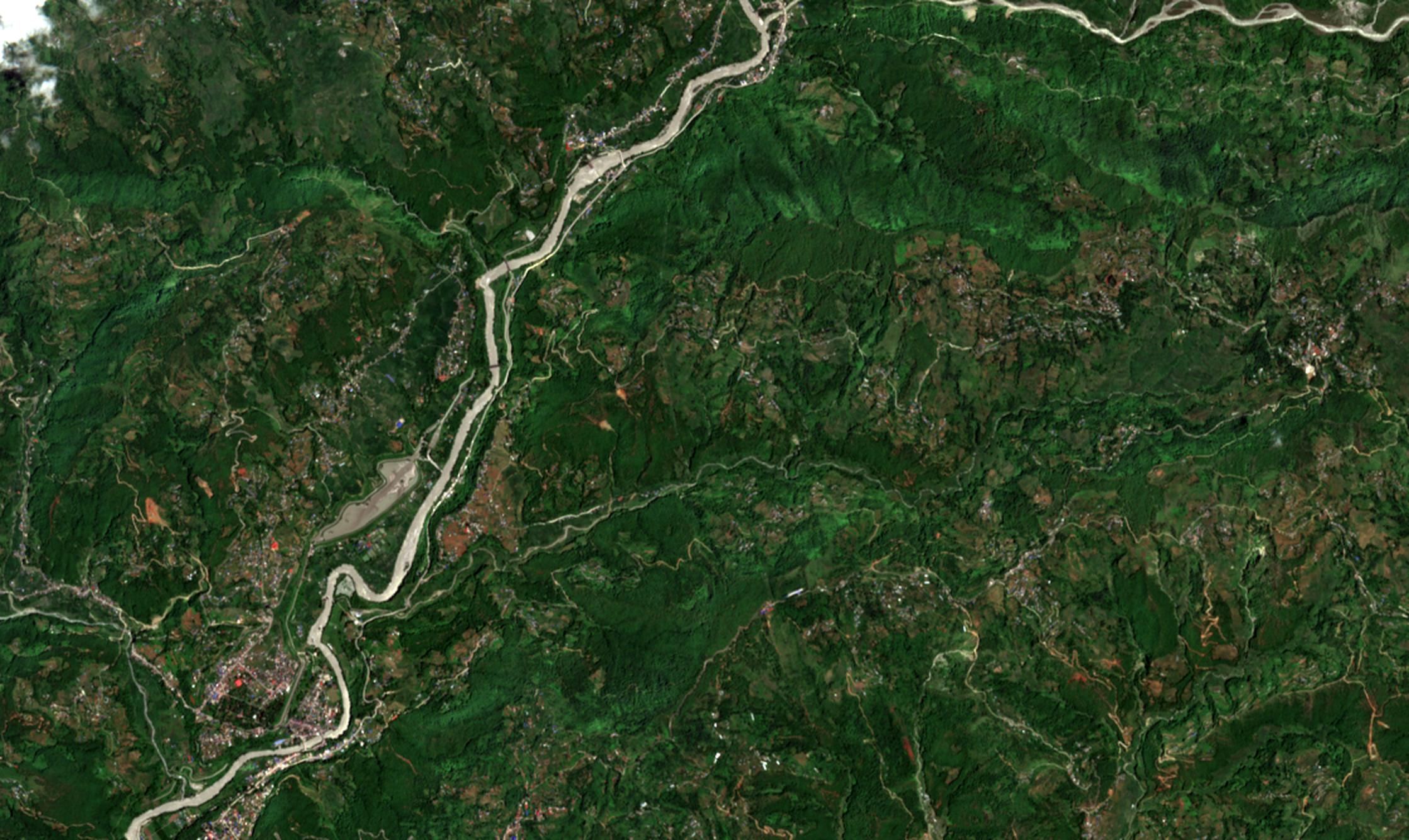
12 Aug 2026 — before
27 Aug 2026 — after
12 Aug 2026 — before
27 Aug 2026 — after
12 Aug 2026 — before
27 Aug 2026 — after
12 Aug 2026 — before
On 26 August 2026 a flood ran about 100 km down the Trishuli river in Nepal. This is eleven kilometres of it, two weeks apart.
This is the river on 12 August: a narrow channel between terraced fields and a town. Keep scrolling and the image becomes 27 August, the day after the flood.
Copernicus Sentinel-2, 12 and 27 August 2026. Same ground, same orbit, same processing, so any difference is a change on the ground. The white patch that appears is cloud, and nothing beneath it can be measured.
Every dot is one building standing here on 12 August. As the image ahead of you turns into 27 August, the buildings the flood destroyed fall away with it.
Copernicus analysts assessed each building individually at 0.3 metres. In this eleven-kilometre reach 1,217 of 1,502 were destroyed, 81% of them. Across the whole study area the figure was 1,826 of 2,343, and all 20 bridges were hit.
of the wider study area was green on 12 August and not green on 27 August. About two fifths of that total lies in this eleven-kilometre stretch, shown in red.
It is 3% of the land whose condition before the flood could be established, and roughly 265 football pitches. The true figure is very likely between 1.22 and 2.63 km².
of the stripped ground lies within 250 metres of the river or a stream feeding it. Within 120 metres, more than half the vegetation went. A kilometre away, 99% survived.
| 0–60 m from the river | 55% | 17× more likely |
| 60–120 m | 59% | 18× |
| 120–250 m | 24% | 7× |
| 250–500 m | 2.5% | below average |
| 500 m – 1 km | 1.0% | below average |
| 1–2 km | 0.2% | below average |
The valley was split into 126 squares of one kilometre, and each was asked whether it held ground that was unmistakably green. Only 75 did. Those 75 patches set the standard. Ground counts as stripped where at least three of four measurements — greenness (NDVI), infrared brightness, wetness (NDWI) and exposed soil (BSI) — fall well below it.
The rule was locked before the Copernicus file was opened. Within the areas their analysts marked as damaged, working from imagery 60 times sharper, the rule found stripped ground in 78% of cases. Where they found no damage, in 1.1%. Their landslide outline is drawn here in yellow.
The rule is cautious by design and misses real damage rather than invent it, so 1.89 km² is a floor. Loosen it to two measurements of four and the area grows to 3.73 km², but it stays in the same place. It also misses the worst ground of all, beside the river, because only 5% of that was green to begin with. This is one stretch of a flood that ran 100 km: across Nepal 626 people were reported dead and 1,924 missing in the days after 26 August, with 561 more dead or missing in Tibet.